FXUS02 KWBC 101938
PMDEPD

Extended Forecast Discussion
NWS Weather Prediction Center College Park MD
338 PM EDT Sat Oct 10 2026

Valid 12Z Tue Oct 13 2026 - 12Z Sat Oct 17 2026


...Heavy rainfall threat continues for the Intermountain West
into Tuesday...

...Record heat for the Southern Plains, Mid-South, and Southeast
Tuesday-Thursday...


...Overview...

An upper low will linger over the Intermountain West into midweek
as anomalous moisture from the Pacific streams in. This will
continue to bring a flash flooding threat across portions of the
Intermountain West into the start of the medium range period on
Tuesday, along with mountain snow. Meanwhile, moisture from ex-
Simon will stream northward, with an expanding area of rain over
the Central U.S. as the western trough drifts slowly eastward.
Despite some model guidance waffling, it appears most likely that
this trough will combine with strong northern stream energy to
establish deep troughing in the east-central U.S. Friday-Saturday.
Before then, strong upper ridging over the south-central to
southeastern U.S. early in the period should allow for much above
normal to record-setting warm temperatures into at least midweek,
slowly moderating with time.


...Guidance/Predictability Assessment...

Model guidance is in good agreement as the medium range period
begins Tuesday, indicating an upper low over the central Great
Basin that gradually drifts east into Wednesday. Meanwhile ridging
will be in place in the southeastern quadrant of the U.S., while a
shortwave or two quickly pass through the northern tier. Model
spread quickly increases for the latter half of the week, as
guidance has struggled with how much northern stream energy from
western Canada will dive southeast into the north-central U.S. and
if it will combine with the preexisting trough. Several 00/06Z
model solutions, other than the GFS, had shown the southern stream
low being left behind in the Southwest while the northern stream
moved more progressively across the U.S./Canada border, without
phasing. However, the bulk of the 12Z guidance now shows more
phasing again (like a day ago), with a stronger trough and
associated surface low moving across the Great Lakes and vicinity.
The 12Z ECMWF seems to be the main model left showing a shallower,
faster northern stream by Friday and less phasing. With the
CMC/GFS/AIGFS/AIFS all now phased again, leaning this way and away
from the ECMWF, plus the ensemble means, seems to represent the
best middle ground forecast. Confidence is relatively low
considering the model changes in the past few cycles.


...Weather/Hazards Highlights...

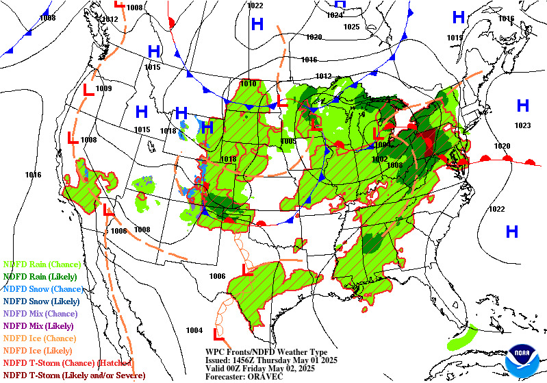
Across the West, the low aloft along with ample moisture from the
Pacific will yield additional widespread modest to locally heavy
rainfall and localized flash flooding into the Great Basin on
Tuesday. See the Excessive Rainfall Outlook for more information.
Cold air surging behind the cold front will lower snow levels,
leading to accumulating snow over higher elevations of the West.
This could be the first appreciable snow for the Utah ranges. Snow
is possible in portions of the Northern/Central Rockies as well
Tuesday-Wednesday and perhaps lingering into Thursday.

A Plains low pressure system and moisture from what is leftover
from Simon may stream northward and aid in producing a widespread
area of rain in the central U.S. beginning Tuesday and likely
lingering through at least Thursday. Thunderstorms and heavy
rain/flooding potential are likely in the Southern/Central Plains
to Lower/Middle Mississippi Valley ahead of a cold front. Farther
north, there is some uncertainty with how progressive the trough
and surface lows could be, but the current forecast is for rain to
shift across the north-central U.S. Wednesday-Thursday and toward
the Northeast Friday.

Elsewhere, a round of rain is possible in the Great Lakes to
Northeast on Tuesday with a shortwave aloft and a cold front.
Florida could see diurnally driven showers and storms later next
week.

Ahead of the front, temperatures in the southern Plains to the
Southeast will be well above normal and likely set new daily high
temperature records (upper 80s to the mid 90s). Low temperatures
may only fall into the 70s for several nights, with the combination
yielding widespread Moderate HeatRisk and perhaps reaching Major
over south Texas. The warmer temperatures in the 90s will gradually
cool back into the 80s as fronts approach. Meanwhile the upper
troughing in the West will bring broadly below average temperatures
there through Tuesday, along with frost/freeze threats. Gradual
warming is likely in the West after that as upper ridging comes in.


Tate/Santorelli


Additional 3-7 Day Hazard information can be found on the WPC
medium range hazards outlook chart at:
https://www.wpc.ncep.noaa.gov/threats/threats.php

WPC medium range 500mb heights, surface systems, weather grids,
quantitative precipitation forecast, excessive rainfall outlook,
winter weather outlook probabilities, heat indices and Key Messages
are at:

https://www.wpc.ncep.noaa.gov/medr/5dayfcst500_wbg.gif
https://www.wpc.ncep.noaa.gov/medr/5dayfcst_wbg_conus.gif
https://www.wpc.ncep.noaa.gov/5km_grids/5km_gridsbody.html
https://www.wpc.ncep.noaa.gov/qpf/day4-7.shtml
https://www.wpc.ncep.noaa.gov/#page=ero
https://www.wpc.ncep.noaa.gov/wwd/pwpf_d47/pwpf_medr.php?day=4
https://www.wpc.ncep.noaa.gov/heat_index.shtml
https://www.wpc.ncep.noaa.gov/#page=ovw


$$
Preferred Height Pattern | SLP Trends