SPC Wind Shear Analysis
Data Courtesy Storm Prediction Center
All Meso-Analysis Maps | Surface Analysis | ENSO | Upper Air Analysis | Thermodynamic Analysis | Severe Analysis | Wind Shear Analysis | Heavy Rain Analysis | Winter Analysis | Beta Analysis
Effective Bulk Wind Difference (kts)
The magnitude of the vector wind difference from the effective inflow base upward to 50% of the equilibrium level height for the most unstable parcel in the lowest 300 mb. This parameter is similar to the 0-6 km bulk wind difference, though it accounts for storm depth (effective inflow base to EL) and is designed to identify both surface-based and "elevated" supercell environments. Supercells become more probable as the effective bulk wind difference increases in magnitude through the range of 25-40 kt and greater.

SFC-3 km Vertical Shear Vector (kts)
Surface-3-km Vertical Shear is the difference between the surface wind and the wind at 3-km above ground level. These data are plotted as vectors with shear magnitudes contoured. 0-3-km shear magnitudes greater than 30 knots may favor QLCS tornadoes.

SFC-6 km Vertical Shear Vector (kts)
The surface through 6-km above ground level shear vector denotes the change in wind throughout this height. Thunderstorms tend to become more organized and persistent as vertical shear increases. Supercells are commonly associated with vertical shear values of 35-40 knots and greater through this depth.

Effective Storm Relative Helicity (m 2 s-2)
Effective SRH (Storm Relative Helicity) is based on threshold values of lifted parcel CAPE (100 J kg-1) and CIN (-250 J kg-1). These parcel constraints are meant to confine the SRH layer calculation to the part of a sounding where lifted parcels are buoyant, but not too strongly capped. For example, a supercell forms or moves over an area where the most unstable parcels are located a couple of thousand feet above the ground, and stable air is located at ground level. The question then becomes "how much of the cool air can the supercell ingest and still survive?" Our estimate is to start with the surface parcel level, and work upward until a lifted parcel's CAPE value increases to 100 Jkg-1 or more, with an associated CIN greater than -250 Jkg-1. From the first level meeting the constraints (the "effective surface"), we continue to look upward in the sounding until a lifted parcel has a CAPE less than 100 Jkg-1 OR a CIN less than -250 J kg-1. Of the three SRH calculations displayed on the SPC mesoanalysis page, effective SRH is the most applicable across the widest range of storm environments, and effective SRH discriminates as well as 0-1 km SRH between significant tornadic and nontornadic supercells.

0-500 m Storm Relative Helicity (m2 s-2)
SRH (Storm Relative Helicity) in the lowest 500 m AGL has been found by Coffer et al. (2019), October issue of Weather and Forecasting, to be a better discriminator than effective SRH between significant tornadoes and nontornadic supercells. This calculation of 0-500 m SRH is limited to within the effective inflow layer, as long as the inflow base is at the ground.

Storm Relative Helicity (m2 s-2) - 0-1km
SRH (Storm Relative Helicity) is a measure of the potential for cyclonic updraft rotation in right-moving supercells, and is calculated for the lowest 1-km and 3-km layers above ground level. There is no clear threshold value for SRH when forecasting supercells, since the formation of supercells appears to be related more strongly to the deeper layer vertical shear. Larger values of 0-3-km SRH (greater than 250 m2 s-2) and 0-1-km SRH (greater than 100 m2 s-2), however, do suggest an increased threat of tornadoes with supercells. For SRH, larger values are generally better, but there are no clear thresholds between non-tornadic and significant tornadic supercells.

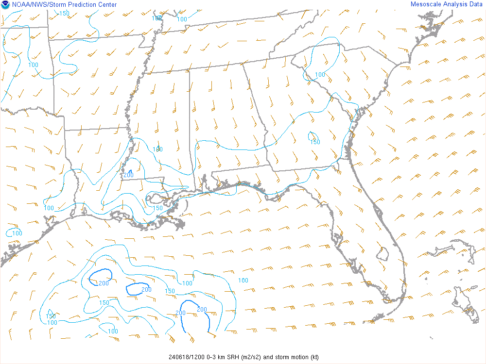
Storm Relative Helicity (m2 s-2) - 0-3km
SRH (Storm Relative Helicity) is a measure of the potential for cyclonic updraft rotation in right-moving supercells, and is calculated for the lowest 1-km and 3-km layers above ground level. There is no clear threshold value for SRH when forecasting supercells, since the formation of supercells appears to be related more strongly to the deeper layer vertical shear. Larger values of 0-3-km SRH (greater than 250 m2 s-2) and 0-1-km SRH (greater than 100 m2 s-2), however, do suggest an increased threat of tornadoes with supercells. For SRH, larger values are generally better, but there are no clear thresholds between non-tornadic and significant tornadic supercells.
850-300mb Mean Wind

Never base important decisions on this or any weather information obtained from the Internet.
Always have a backup method of receiving weather information such as a battery powered weather radio.
Copyright © 2026 DaculaWeather.com
