


Georgia Christmas Weather Climatology
Everyone is always interested in the weather around the Christmas holidays. So I thought I'd share some information about the Christmas climatology for the north Georgia area. And of course the most frequently asked question is... "Are we going to have a white Christmas?". Let us take a look at the NWS data.
Although we have had some very cold Christmases, records show that a White
Christmas is rare in Georgia. However, we do not have to go back too far for Georgia's history to see the last white
Christmas for Atlanta was 2010! Most of the snow on Christmas Day 2010 fell across extreme north Georgia with
6 to 7 inches quite common from Trenton to Blairsville. However snow was seen as far south as central Georgia. Columbus
tied a record snowfall for Christmas Day of a trace, previously set in 1970. Athens and Macon both set new records for
snowfall for that day. Athens new record snowfall of 2.0 inches on Christmas Day 2010 broke their previous record of 0.2
inches set in 1993. In Macon, the 0.1 inches that fell in 2010 was the very first snowfall they have seen on Christmas
Day...ever!
We had snow here in Big Canoe on December 26-27th, 2022, so it was like a White Christmas!
Climatological Odds by Sub-Region
-
Higher Elevations / True Mountains (e.g., Blairsville, Helen, Clayton, above ~2,500-3,000 ft):
15%-25% chance
Highest odds in the state. Snow on the ground on Christmas Day is uncommon but not rare in strong cold patterns. Last widespread mountain White Christmas: 2010. -
Lower Mountains / Foothills (e.g., Nelson, Dahlonega, Ellijay, Jasper, Dawsonville, Blue Ridge, ~1,500-2,500 ft):
5%–12% chance -
North Atlanta Metro Fringe / Lower North Georgia (e.g., Marietta, Roswell, Alpharetta, Cumming, Canton, north Gwinnett/Forsyth, ~1,000-1,500 ft):
2%-5% chance
Very low odds. A White Christmas here requires a rare, deep cold surge and perfect moisture timing. Last measurable snow on Dec 25 near Atlanta: 1989 (coastal event with traces to light snow in north suburbs).
Key Factors That Influence Odds
-
Required Ingredients:
- Deep Arctic air mass (surface temps less than or equal to 28F, ideally teens to 20s) on Christmas Eve-Day.
- Sufficient Gulf/Atlantic moisture to produce measurable precip (at least 0.1-0.2 inches liquid equivalent).
- High snow ratios (12:1 to 20:1+) from cold, dry air - common in north Georgia when cold air is deep.
-
Historical Frequency:
- North Georgia mountains: Roughly 1 in 4 to 1 in 6 years have ≥1 inch on Dec 25.
- Lower north Georgia / metro fringe: Roughly 1 in 20 to 1 in 40 years.
-
Typical Snow Depth on Dec 25:
- Most years: 0 inches (green Christmas).
- Trace to less than 1 inch: Occasional.
- 1+ inches: Rare, usually tied to a strong cold wave (e.g., 1989, 2010).
-
Bottom Line:
- Mountains/Foothills (Blairsville, Dahlonega, Ellijay, etc.): Low to moderate chance (~15%-25%) - possible in a favorable cold pattern.
- Lower North Georgia / North Atlanta suburbs (Nelson, Cumming, Roswell, etc.): Very low chance (less than 5%-10%) - would require an exceptional setup.
- Overall: A White Christmas is uncommon across north Georgia, with the best odds in the higher elevations. The most likely outcome is a green or trace Christmas, with any snow more probable during a brief cold snap.
These are climatological averages and do not reflect the specific 2025-2026 forecast (which would require late-fall/early-winter guidance).
Christmas Snowfall
| Snowfall on Christmas Day | ||||
| Atlanta | Athens | Macon | Columbus | |
| Number of Days Snowfall greater than or equal to 0.01": | 3 | 2 | 1 | 0 |
| Number of Days Snowfall = Trace: | 13 | 1 | 0 | 2 |
Record Christmas Snowfall
| Record Snowfall on Christmas Day | ||||
| Atlanta | Athens | Macon | Columbus | |
| Snow Amount: | 1.3 | 2.0 | 0.1 | Trace |
| Year of Occurrence: | 2010 | 2010 | 2010 | 2010 |
Record Precipitation for Christmas
Although Christmas is often dry, some rainy Christmases have occurred. The heaviest rainfall recorded on Christmas Day at climate recording sites in north Georgia has exceeded 2 inches. The record rainfall amounts for the date are in the following table.
| Record Precipitation on Christmas Day | ||||
| Atlanta | Athens | Macon | Columbus | |
| Precipitation (inches): | 2.06 | 2.52 | 2.68 | 3.32 |
| Year of Occurrence: | 1945 | 1945 | 1964 | 1964 |
Temperatures for Christmas
On average, high temperatures ranged from the mid 40s across north Georgia to the mid 60s across central Georgia. The average low temperatures range from the mid 20s across north Georgia to the mid 40s across central Georgia. However, days of Christmas past have been quite warm with the record high temperatures in the 70s across north and central Georgia. We have also seen bitterly cold Christmas days where record low temperatures were in the single digits.
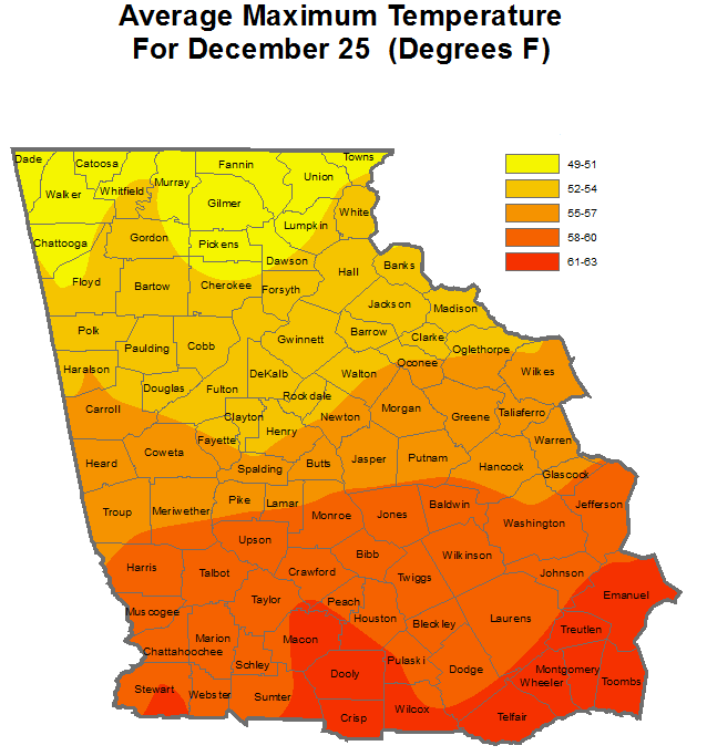 Avearage Maximum Temperature for Dec. 25th |
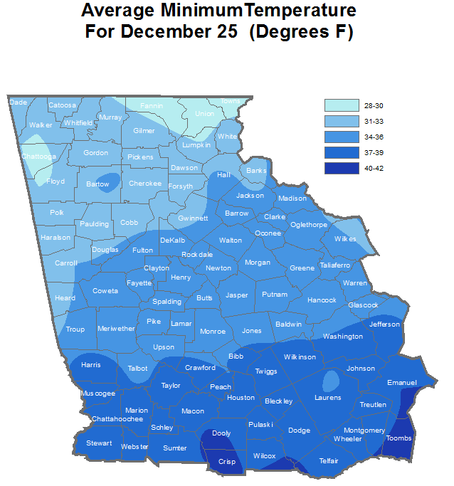 Average Minimum Temperature for Dec. 25th |
*The above data is based on climate and coop stations with at least 20 years of data. |
|
We have seen temperatures a lot colder and a lot warmer than our averages, though! Highs have been as warm as the 70's and lows as cold as the single digits! See the table below for record highs and lows on Christmas across our area.
