Georgia White Christmas - December 25, 2010
Data from NWS Atlanta and the Weather Prediction Center


Event Summary
The 2010 White Christmas in Georgia (primarily December 24–26, 2010) was a rare and memorable holiday snow event, especially across north and central Georgia. It was part of a broader cold and snowy pattern across the Southeast in late December 2010, driven by a strong Arctic outbreak and moisture from a stalled frontal boundary/overrunning system. For many in north Georgia (including the mountains and foothills), it was one of the better Christmas snow events in recent decades, with accumulations of 1–8 inches in higher elevations and traces to 2–4 inches in lower areas and the Atlanta metro fringe. The event produced a true **White Christmas** (measurable snow on December 25) for parts of the state—the first widespread one since 1989 in some areas.
Meteorological Setup
A deep Arctic air mass (from a polar vortex influence) entrenched across the eastern U.S. in late December 2010, with surface temperatures in the teens to 20s°F across Georgia. A stalled frontal boundary and weak upper-level disturbance provided modest Gulf/Atlantic moisture to produce light to moderate precipitation over the cold air. The event was primarily light overrunning snow rather than a classic coastal low or heavy deformation band, but the deep, dry cold air supported very high snow ratios (15:1 to 20:1+), allowing small liquid equivalents to produce noticeable accumulations. Snow began Christmas Eve afternoon/evening, peaked Christmas morning (December 25), and lingered with flurries/cold through Boxing Day (December 26).
Snowfall Amounts and Distribution
The shape of a snowflake depends heavily on the temperature of the layer in which it grows:
- North Georgia Mountains/Foothills: (e.g., Blairsville, Dahlonega, Ellijay, Blue Ridge, Jasper, Helen): 3–8 inches common; higher elevations (e.g., near Brasstown Bald, Blood Mountain, or Vogel State Park) up to 6–10 inches in upslope-enhanced spots.
- Union, Fannin, Gilmer, Pickens, Lumpkin, White Counties: Widespread 3–6 inches; some isolated higher totals in mountains.
- Dawson, Forsyth, Cherokee, Hall Counties: 2–5 inches.
- Atlanta Metro Fringe / Lower North Georgia: (e.g., north Fulton, Gwinnett, Cobb, Bartow): Trace to 1–3 inches; some areas saw mostly sleet or flurries with little accumulation.
- Central Georgia: Some areas topped 20 inches total for the week.
Many locations saw more snow than typical for December, with the event producing a white Christmas for the first time in years for parts of north Georgia.
Temperature Records
- North Georgia: Christmas Eve–Day lows in the teens to single digits (e.g., Blairsville area 10–15°F); highs only in the 20s–low 30s°F on Christmas Day.
- Atlanta Metro: Lows around 15–20°F; highs in the 20s–30s°F on December 25.
- No all-time December records were set, but the cold was among the most prolonged for late December in recent years, preserving snow cover through Boxing Day.
Impacts
- Transportation: Slick roads and ice on bridges/highways; some school delays/closures extended into post-holiday; minor accidents; rural mountain roads hazardous (e.g., in Union/Fannin counties).
- Utilities and Infrastructure: Minor power outages from ice on lines in higher elevations; frozen pipes in unheated areas.
- Human Toll: No major fatalities reported in Georgia; exposure risks high in rural mountain areas.
- Economic: Holiday travel disrupted; some agriculture concerns from freeze (though not as severe as 1989 or 1985).
- Other Disruptions: Rare white Christmas scenes cherished (photos of snow-covered north Georgia mountains and towns); kids enjoyed sledding; many power outages avoided due to light precip.
Other Notes of Interest
- Rarity and Legacy: A true White Christmas (measurable snow on December 25) is rare in Georgia (last widespread one before 2010 was 1989, but that was coastal-heavy). This event is fondly remembered in the north Georgia mountains for holiday snow without the extreme chaos of 2014 Snowmageddon or 1982 Snow Jam.
- Unusual Phenomena: High snow ratios (15:1+) from deep cold air; light precip produced decent accumulations; mountain enhancement (upslope lift) boosted totals in Fannin/Union counties.
- Cultural Impact: Social media/photos of snow-covered north Georgia towns went viral (early Facebook era); many families called it a "perfect Christmas surprise."
- Comparisons: Unlike heavy coastal snow of 1989 or the urban chaos of 2014, 2010 was a lighter, scenic mountain snow event - memorable but far less disruptive.: Unlike heavy coastal snow of 1989 or the urban chaos of 2014, 2010 was a lighter, scenic mountain snow event - memorable but far less disruptive.
Meteorological Overview
From December 25, 2010 through December 27, a strong low pressure system produced significant snowfall across much of the Southeastern U.S. and the East Coast, along with very strong winds across the Northeast. Precipitation began in the Southeastern US during the early morning hours of December 25. Most of the precipitation was in the form of rain during this time, with snowfall first observed around 5 AM CST in northern Alabama and Mississippi. Snowfall would gradually spread north and east throughout the day, reaching as far north as the Delmarva Peninsula by late that night. As the storm began to move up the US East Coast on December 26, the snowfall began to intensify across the coastal regions of the Mid-Atlantic states. Heavy snow finally reached the Northeast on the evening of the 26th and persisted for several hours before precipitation finally came to an end a day later.
Over Georgia, Precipitation began Christmas Eve, quickly changing from rain to snow across extreme north Georgia. For the rest of north and central Georgia, the changeover occurred from northwest to southeast during the day on Christmas Day as temperatures dropped to near freezing. The highest accumulations occured in the north Georgia mountains, where anywhere between 6 and 8 inches of snow were reported, but even the Atlanta Metro area saw between 1-3 inches - the first measurable snow on Christmas Day since 1881. As the system slowly moved east, snow continued on the 26th resulting in additional accumulations across east central Georgia.
Very cold temperatures moved in behind the system and any moisture on the roads froze overnight Christmas night, causing significant road problems. Strong winds, at times gusting to between 25-35 mph, also spread across the area on the 26th. With high temperatures across most of north Georgia below freezing, wind chills in the single digits were noted throughout the day. Flurries and light snow continued through the 26th for most of the area as the storm system moved up the East Coast.
Figure 1 below shows a map of snowfall totals observed with this storm.
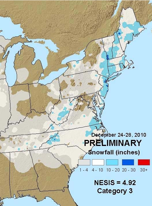
Note the large swath of significant snowfall extending from North Carolina northeast through Maine. Major metropolitan regions affected by this storm include Raleigh, Norfolk, Philadelphia, New York City, and Boston. This storm was of historical proportions for several of these locations, and is now ranked as the third snowiest event of all time for both Norfolk, VA and Newark, NJ as well as the sixth snowiest event for New York City’s Central Park. It was also rated as a Category 3 on the Northeast Snowfall Impact Scale. Northern New Jersey received the most snow, with 32 inches being observed at Rahway and many locations receiving over two feet. Of particular significance was the fact that this storm occurred during and immediately after the Christmas holiday, which is a time of increased travel across the U.S. Over 6,000 flights to and from East Coast cities were canceled and all three major airports in the New York metro area were closed simultaneously during the storm. In addition, after New York’s JFK Airport reopened, twenty-eight flights arriving from international destinations were stranded on the tarmac for up to eleven hours due to the backlog of flights. The following sections will examine the meteorology behind this impressive storm.
Synoptic Setup
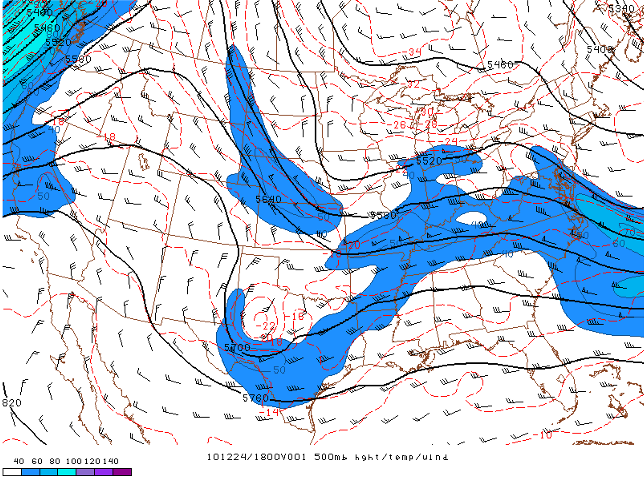
On December 24, 2010, a strong upper-level ridge of high pressure began to build over the western United States in response to an approaching trough from the Pacific. As this occurred, shortwave troughs embedded in the northern and southern streams began to dive down the backside of the strengthening ridge, moving into the plains by 18Z on the 24th (see Figure 2 below).
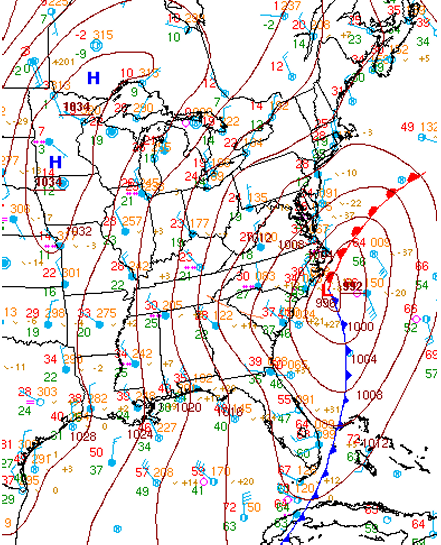
The southern stream shortwave proceeded to move eastward while the northern stream trough amplified and began to dive southward towards the southern stream. At the surface, low pressure associated with the southern stream shortwave was also moving eastward (see Figure 3).

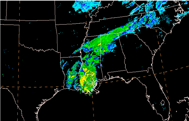
Cold high pressure then settled in to the north of this system as the northern stream trough moved southward. By 12Z on the 25th, the anomalously deep northern stream trough had allowed freezing temperatures at 850 mb to reach as far south as northern Louisiana and central Mississippi. The cold air would penetrate even farther south as the northern trough continued to amplify, setting the stage for snow across the southeast. The southward movement of cold air coincided with the formation of a band of precipitation across the southeast, which was associated with warm air advection and frontogenesis in a deformation zone north of the developing surface cyclone (see Figure 4).
Aiding in the development of this feature was an upper level jet-streak associated with the northern stream trough (see Figure 5).
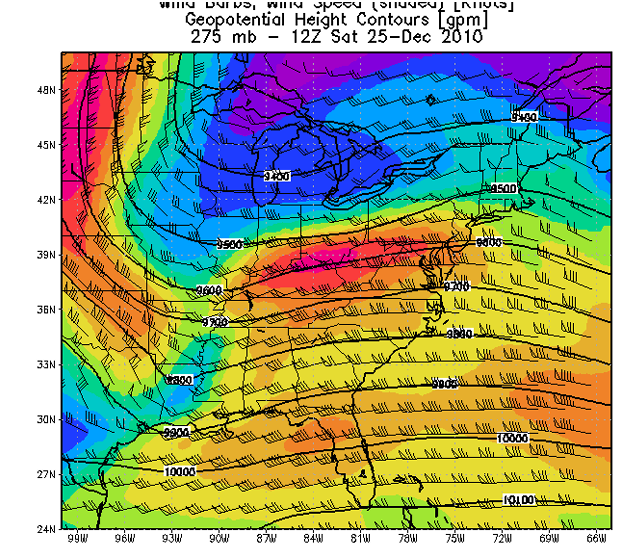
The right entrance region of a jet streak is usually associated with enhanced vertical motion (Moore and Vanknowe 2429). This vertical motion was able to aid in the development of this band of snow, which produced significant amounts of snow over portions of northern Alabama, Mississippi, and Georgia as well as portions of Tennessee and North Carolina.
By 00Z on the 26th, the two shortwaves had merged, forming one amplified trough over the eastern United States. As this occurred, the associated surface low pressure system began to deepen significantly and move northeast up the Atlantic coastline (see Figure 6). Both the advection of lower thicknesses behind the strengthening cyclone and the strengthening Western U.S. ridge helped the upper trough intensify into a large upper low by 12Z, which began to slowly move eastward over the Appalachians (see Figure 7).
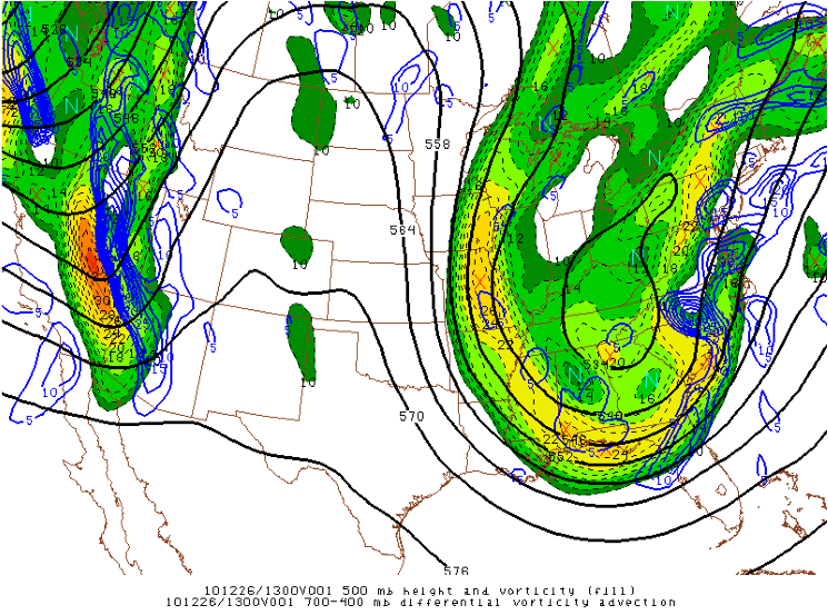
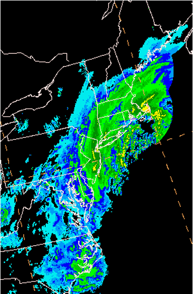
As this occurred, areas of differential positive vorticity advection (DPVA) and warm air advection overspread the southern Mid-Atlantic states, creating large scale lift over the area. In addition, two strong jet streaks had set up over the eastern seaboard by 12Z. At this time, the entrance region of the northern jet streak and the exit region of the southern jet streak were located over northeastern North Carolina and southeastern Virginia (see Figure 8). These two regions are favorable for synoptic scale lift (Moore and Vanknowe 2432), and their presence over this region aided in the development of heavy snow over locations such as Norfolk, VA (see Figure 9).

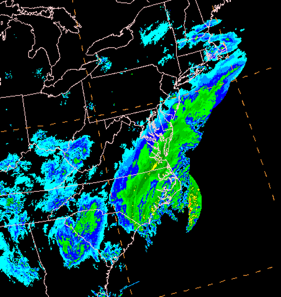
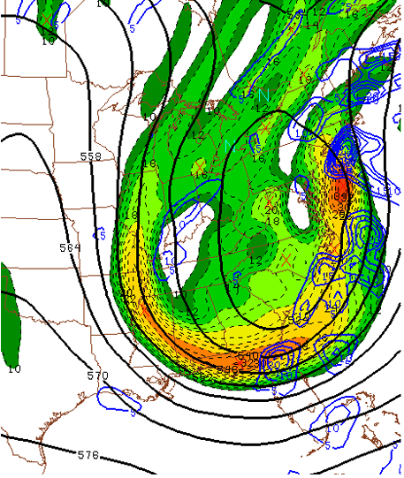
The surface low pressure system then continued to move northeast, intensifying along with the associated upper level low. As this occurred, the two aforementioned jet streaks also moved northeast so that their entrance and exit regions, some of which are favorable for large-scale lift, moved offshore. However, the upper low was still located near the US East Coast, and was creating large areas of DPVA over the Northeast (see Figure 10). This setup ensured that enough synoptic-scale lift was present over the area to allow for a persistent large swath of heavy snow (see Figure 11).
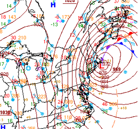
In addition to the heavy snow, very strong winds were present across the Northeast at this time, leading to near whiteout conditions as well as blowing and drifting snow. Gusts over 60 mph were observed across the New York City metro area and New England, and winds reached as high as 80 mph along Cape Cod. These winds resulted from the strong pressure gradient forces created by the nearby passage of the rapidly intensifying surface low. The WPC surface analysis valid at 09Z on December 27 is shown in Figure 12 below to illustrate just how strong this pressure gradient was. Note the incredible packing of the isobars across the Northeast. These were the areas that saw the strongest winds.
Mesoscale Pattern
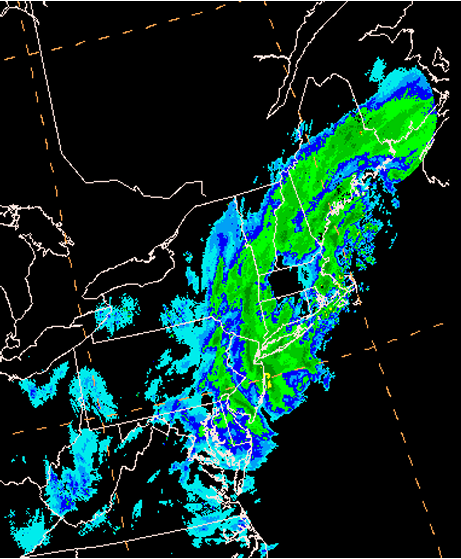
While the synoptic forcing played a large role in producing significant snowfall with this system, mesoscale forcing also provided a significant contribution. As the storm moved up the Atlantic Coast, a strong shear axis developed north of the low center in the low to mid levels of the atmosphere. Strong easterly winds carried warm air inland from the Atlantic. These winds met strong northerly winds, which were advecting cold air southward. The result was strong convergence across a large temperature gradient, which resulted in significant frontogenesis. Frontogenesis creates a circulation in the atmosphere where air rises on the warm side of the front and sinks on the cold side (Sanders & Bosart). The lift induced by this circulation was a significant factor in the creation of heavy snow bands across the East Coast. Southeastern Virginia and northeastern North Carolina were the first regions to benefit from this added forcing (see Figure 13).
Southeastern Virginia and northeastern North Carolina were not the only regions to benefit from frontogenetical forcing. As mentioned previously, mesoscale forcing likely played a major role in generating the incredible snowfall totals seen across portions of the Northeast. Note the band of heavy precipitation across New Jersey and southern New York at 23Z on December 26 (see Figure 11). In particular, notice how this band is embedded in the larger swath of precipitation created by the synoptic-scale forcing discussed in the previous section. Seven hours later, much of this precipitation had moved north into Maine and New Hampshire (see Figure 14). However, the band of heavy snow was still present over northern New Jersey and portions of Upstate New York, even though the main region of precipitation had moved northward.
To understand why this occurred, the mesoscale pattern must be examined. Figure 15 shows regions of 850mb frontogenesis and instability at 23Z on December 26. Notice the area of extremely strong frontogenesis over the Northeast, as well as the CSI present over the northern Mid-Atlantic Coast and southern New York State. This coincides very well with the band of heavy snow seen in Figure 11 over this region, indicating that frontogenetical forcing played a major role in the development of this band. It was during this period that New York City observed thundersnow, which is indicative of the intense convection resulting from this combination of strong forcing and instability.
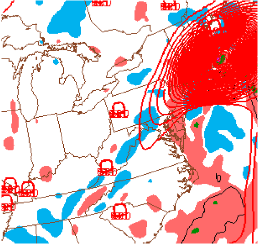
Figure 16 shows the same parameters seven hours later. Notice how frontogenesis and instability have lingered over the northern Mid-Atlantic states even though the main area of frontogenesis has moved further north. This lingering area of mesoscale forcing explains the persistence of this band over northern New Jersey, which allowed it to produce snow totals as high as 32 inches.
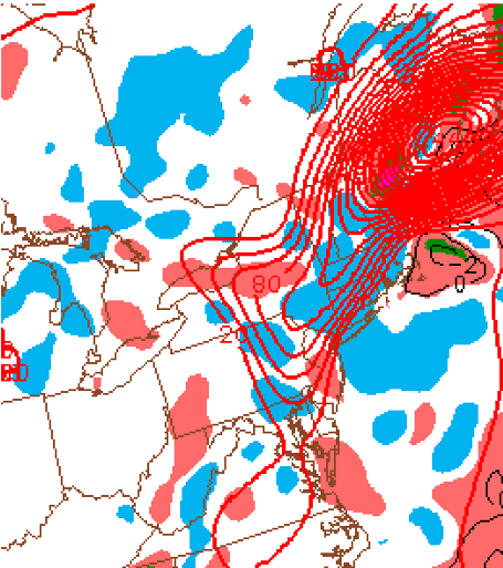
Frontogenesis was also present at the 700mb level (not shown), and this allowed for a band of heavy snow to set up across northern New England as well. While this band was not quite as intense as the band across northern New Jersey, snow totals of 20 inches or greater were not uncommon across Vermont and New Hampshire.
Conclusion
A strong low pressure system tracked up the US East Coast from December 25-27, 2010, producing snowfall across a large area from the Deep South to New England, which included some of the country’s most densely populated regions. Very strong synoptic forcing induced by jet dynamics and an unusually deep upper low allowed for the development of a large swath of snowfall across this region. This synoptic-scale lift would combine with vigorous frontogenetical forcing to produce persistent bands of heavy snowfall over certain regions, leading to localized snowfall totals of up to two and a half feet. The impacts of this storm were both substantial and far-reaching, making this storm one of the most significant of the season.
Moore, James T., Glenn E. Vanknowe, 1992: The Effect of Jet-Streak Curvature on Kinematic Fields. Mon. Wea. Rev., 120, 2429, 2432.
Sanders, Frederick, Lance F. Bosart, 1985: Mesoscale Structure in the Megalopolitan Snowstorm of 11–12 February 1983. Part I: Frontogenetical Forcing and Symmetric Instability. J. Atmos. Sci., 42, 1050–1061.
Georgia Snow Totals

Storm Track

North Carolina Snow Amounts

Alabama Snow Amounts

PUBLIC INFORMATION STATEMENT - UPDATED - 610 PM EST SUN DEC 26 2010
	NOUS42 KFFC 262308
PNSFFC
GAZ001>009-011>016-019>025-027-030>039-041>062-066>076-078>086-
089>098-102>113-271200-

PUBLIC INFORMATION STATEMENT...UPDATED
NATIONAL WEATHER SERVICE PEACHTREE CITY GA
610 PM EST SUN DEC 26 2010

THE FOLLOWING ARE UNOFFICIAL OBSERVATIONS TAKEN DURING THE RECENT
SNOWSTORM. APPRECIATION IS EXTENDED TO EMERGENCY MANAGERS...COUNTY
911 OPERATORS...COOPERATIVE OBSERVERS...SKYWARN SPOTTERS AND MEDIA
FOR THESE REPORTS. THIS SUMMARY IS ALSO AVAILABLE ON OUR HOME PAGE
AT WEATHER.GOV/ATLANTA.

********************STORM TOTAL SNOWFALL********************

LOCATION          STORM TOTAL     TIME/DATE   COMMENTS
                     SNOWFALL           OF
                     /INCHES/   MEASUREMENT

GEORGIA

...DADE COUNTY...
   TRENTON                6.0   200 PM 12/25  IN THE MOUNTAINS.

...WALKER COUNTY...
   LAFAYETTE              5.0   700 PM 12/25  4-5 INCHES WIDESPREAD.

...CATOOSA COUNTY...
   RINGGOLD               6.0   200 PM 12/26
   RINGGOLD 5.0 W         5.0   800 AM 12/26  COCORAHS
   RINGGOLD 2.8 SW        4.7   700 AM 12/26  COCORAHS

...WHITFIELD COUNTY...
   DALTON                 3.0   200 PM 12/26
   COHUTTA                4.0   700 PM 12/25  3.5 TO 4 INCHES.

...MURRAY COUNTY...
   ETON                   4.0   200 PM 12/26  3 TO 4 INCHES ACROSS
                                              LOWER ELEVATIONS.
   FORT MOUNTAIN STATE    7.0   200 PM 12/26  6 TO 7 INCHES ON THE
   PARK                                       MOUNTAIN.
   CHATSWORTH             3.0   700 AM 12/26  COOP

...GILMER COUNTY...
   ELLIJAY                5.0   200 PM 12/26  4 TO 5 INCHES ACROSS
                                              LOWER ELEVATIONS.
   CHERRY LOG             7.0   200 PM 12/26  6 TO 7 INCHES ACROSS
                                              HIGHER ELEVATIONS.

...FANNIN COUNTY...
   BLUE RIDGE             6.0   700 PM 12/25  WIDESPREAD 5-6 INCHES.

...UNION COUNTY...
   BLAIRSVILLE            6.0   700 PM 12/25
   SUCHES                 7.0   800 PM 12/25
   BLAIRSVILLE 4.2 E      4.5   900 AM 12/26  COCORAHS
   SUCHES 8 NW            6.0   700 AM 12/26  COOP

...TOWNS COUNTY...
   HIAWASSEE              6.0   700 PM 12/25  5-6 INCHES WIDESPREAD.

...CHATTOOGA COUNTY...
   SUMMERVILLE            4.0   200 PM 12/26
   LYERLY 4.8 SSE         2.3   800 AM 12/26  COCORAHS

...GORDON COUNTY...
   CALHOUN                3.0   700 PM 12/25

...PICKENS COUNTY...
   JASPER                 4.0   200 PM 12/26  2 TO 4 INCHES ACROSS
                                              THE COUNTY.
   JASPER                 4.0   700 AM 12/26  COOP

...DAWSON COUNTY...
   DAWSONVILLE            5.0   200 PM 12/26  3 TO 5 INCHES ACROSS
                                              THE COUNTY.
   EMMA 4.3 WNW           4.0   800 AM 12/26  COCORAHS

...LUMPKIN COUNTY...
   DAHLONEGA              4.0   200 PM 12/26  2 TO 4 INCHES ACROSS
                                              THE SOUTHERN PART OF
                                              THE COUNTY.
   CAMP MERRILL           6.0   200 PM 12/26  AT THE HIGHER ELEVATIONS.
   DAHLONEGA 6.4 NW       2.2   700 AM 12/26  COCORAHS

...WHITE COUNTY...
   HELEN                  3.0   200 PM 12/26
   HELEN 9.5 ENE          2.5   800 AM 12/26  COCORAHS
   SAUTEE 3.5 SW          2.5   700 AM 12/26  COCORAHS
   SAUTEE                 2.3   700 AM 12/26  COOP
   CLEVELAND              2.0   700 AM 12/26  COOP

...FLOYD COUNTY...
   ROME                   3.0   700 PM 12/25  WIDEPSREAD 2-3 INCHES.
   ROME 3.7 E             1.5   700 AM 12/26  COCORAHS
   CURRYVILLE             1.0   700 AM 12/26  COOP

...BARTOW COUNTY...
   CARTERSVILLE           3.0   200 PM 12/26
   ADAIRSVILLE            2.0   700 AM 12/26  COOP

...CHEROKEE COUNTY...
   CANTON                 3.0   700 PM 12/25  2-3 INCHES ACROSS
                                              THE COUNTY.
   WOODSTOCK 3.3 NNE      3.5   800 AM 12/26  COCORAHS
   HOLLY SPRINGS 1.0 NNE  3.0   700 AM 12/26  COCORAHS
   CANTON                 2.0   700 AM 12/26  COOP

...FORSYTH COUNTY...
   CUMMING                3.0   200 PM 12/26  2 TO 3 INCHES ACROSS
                                              THE COUNTY.
   CUMMING 5.7 SSW        2.0   700 AM 12/26  COCORAHS
   CUMMING 3.5 E          1.5   700 AM 12/26  COCORAHS

...HALL COUNTY...
   GAINESVILLE            3.0   200 PM 12/26  2 TO 3 INCHES ACROSS
                                              THE COUNTY.
   CLERMONT 1.0 SSE       2.0   700 AM 12/26  COCORAHS
   GAINESVILLE 6.1 NNW    1.7   730 AM 12/26  COCORAHS
   GAINESVILLE            1.0   700 AM 12/26  COOP

...BANKS COUNTY...
   COMMERCE               4.0   400 PM 12/26

...JACKSON COUNTY...
   JEFFERSON              4.0   200 PM 12/26  3 TO 4 INCHES ACROSS
                                              THE COUNTY.
   NICHOLSON 4.2 S        1.7   800 AM 12/26  COCORAHS

...MADISON COUNTY...
   DANIELSVILLE           3.0   200 PM 12/26
   NICHOLSON 5.7 SE       2.8   735 AM 12/26  COCORAHS
   COMER 3.5 NE           2.0   820 AM 12/26  COCORAHS
   NICHOLSON 4.9 SE       1.8   700 AM 12/26  COCORAHS
   DANIELSVILLE           3.1   700 AM 12/26  COOP

...POLK COUNTY...
   CEDARTOWN              3.0   200 PM 12/26  2 TO 3 INCHES ACROSS
                                              THE COUNTY.
   ROCKMART 9.6 SSE       4.5   500 AM 12/26  COCORAHS
   CEDARTOWN 1.3 NE       2.0  1100 AM 12/26  COCORAHS

...HARALSON COUNTY...
   BUCHANAN               2.0   700 PM 12/25

...PAULDING COUNTY...
   DALLAS 2.5 N           3.0   700 AM 12/26  COCORAHS
   DALLAS                 4.0   700 AM 12/26  COOP

...COBB COUNTY...
   ACWORTH                2.0   848 PM 12/25
   MARIETTA 7.0 NNE       2.7   900 AM 12/26  COCORAHS
   MARIETTA 8.3 NE        1.5   820 AM 12/26  COCORAHS
   MABELTON               1.0   700 AM 12/26  COOP

...FULTON COUNTY...
   ROSWELL 1.0 NNW        2.0   800 AM 12/26  COCORAHS
   FAIRBURN 0.6 NW        1.7   818 AM 12/26  COCORAHS
   ATLANTA 9 NW           1.0   700 AM 12/26  COOP
   ALPHARETTA 4 SSW       2.0   700 AM 12/26  COOP

...GWINNETT COUNTY...
   LILBURN                1.5   200 PM 12/26
   DACULA 2.8 SE          2.1   645 AM 12/26  COCORAHS
   BUFORD 4.6 ESE         2.0   945 AM 12/26  COCORAHS
   LAWRENCEVILLE          1.4   700 AM 12/26  COCORAHS

...BARROW COUNTY...
   WINDER                 4.0   200 PM 12/26  2 TO 4 INCHES ACROSS
                                              THE COUNTY.
   STATHAM                4.0   200 PM 12/26

...OCONEE COUNTY...
   BOGART                 3.0   200 PM 12/26
   BISHOP 3.0 WNW         2.0   700 AM 12/26  COCORAHS

...CLARKE COUNTY...
   ATHENS                 3.0   200 PM 12/26
   ATHENS 7.6 SE          3.0   700 AM 12/26  COCORAHS
   ATHENS 3.2 NW          2.5   700 AM 12/26  COCORAHS
   WINTERVILLE            0.6   700 AM 12/26  COOP

...OGLETHORPE COUNTY...
   LEXINGTON              4.0   200 PM 12/26  2 TO 4 INCHES ACROSS
                                              THE COUNTY.
   COLBERT 3.1 SSE        1.5   700 AM 12/26  COCORAHS
   LEXINGTON              1.0   700 AM 12/26  COOP

...WILKES COUNTY...
   WASHINGTON             1.5   700 AM 12/26  COOP
   WASHINGTON             4.0   400 PM 12/26  2 TO 4 INCHES ACROSS
                                              THE COUNTY.

...CARROLL COUNTY...
   VILLA RICA             3.0   945 PM 12/25
   TEMPLE 0.7 E           2.5   700 AM 12/26  COCORAHS
   CARROLLTON 3.2 SW      2.0   800 AM 12/26  COCORAHS
   CARROLLTON             2.0   700 AM 12/26  COOP

...DOUGLAS COUNTY...
   CHAPEL HILL            1.5   831 PM 12/25
   DOUGLASVILLE 0.2 N     2.0   530 AM 12/26  COCORAHS

...DEKALB COUNTY...
   DECATUR                0.5   200 PM 12/26
   NORTH DECATUR 3.0 NNE  2.5   700 AM 12/26  COCORAHS
   DUNWOODY 1.1 NW        1.6   829 AM 12/26  COCORAHS

...WALTON COUNTY...
   LOGANVILLE 4.0 SSE     1.6   700 AM 12/26  COCORAHS

...HEARD COUNTY...
   FRANKLIN               1.0   200 PM 12/26  0.5 TO 1 INCH.

...COWETA COUNTY...
   NEWNAN                 1.0   400 PM 12/26
   NEWNAN                 0.7   700 AM 12/26  COOP

...FAYETTE COUNTY...
   FAYETTEVILLE           2.0   200 PM 12/26

...CLAYTON COUNTY...
   HARTSFIELD-JACKSON     1.5   200 PM 12/26
   JONESBORO              T     200 PM 12/26

...HENRY COUNTY...
   MCDONOUGH              T     700 AM 12/26  COOP
   STOCKBRIDGE            1.0   400 PM 12/26

...NEWTON COUNTY...
   COVINGTON              1.0   400 PM 12/26

...MORGAN COUNTY...
   MADISON                3.0   400 PM 12/26  2 TO 3 INCHES ACROSS
                                              THE COUNTY.

...GREENE COUNTY...
   GREENSBORO             4.0   400 PM 12/26  3 TO 4 INCHES ACROSS
                                              THE COUNTY.

...TALIAFERRO COUNTY...
   CRAWFORDVILLE          4.0   400 PM 12/26  3 TO 4 INCHES ACROSS
                                              THE COUNTY.

...SPALDING COUNTY...
   GRIFFIN                1.0   400 PM 12/26

...BUTTS COUNTY...
   JACKSON                0.5   200 PM 12/26

...JASPER COUNTY...
   MONTICELLO             0.5   400 PM 12/26

...PUTNAM COUNTY...
   EATONTON               0.5   400 PM 12/26

...HANCOCK COUNTY...
   SPARTA                 1.5   400 PM 12/26  0.5 TO 1.5 INCHES.

...WARREN COUNTY...
   WARRENTON              0.5   400 PM 12/26

...TROUP COUNTY...
   LA GRANGE              1.0   655 PM 12/25

...MERIWETHER COUNTY...
   GREENVILLE             1.0   400 PM 12/26

...PIKE COUNTY...
   ZEBULON                0.5   400 PM 12/26

...MONROE COUNTY...
   FORSYTH                T     200 PM 12/26

...BALDWIN COUNTY...
   MILLEDGEVILLE          1.0   700 AM 12/26  COOP

...UPSON COUNTY...
   THOMASTON              0.5   200 PM 12/26
   THOMASTON              0.3   700 AM 12/26  COOP

...BIBB COUNTY...
   MACON                  T     200 PM 12/26

...MUSCOGEE COUNTY...
   COLUMBUS               T     700 AM 12/26  COOP
Never base important decisions on this or any weather information obtained from the Internet.
Always have a backup method of receiving weather information such as a battery powered weather radio.
Copyright © 2026 DaculaWeather.com
